Today - 11 August 2025
Now - 07:38:08
Now - 07:38:08
What part of Russia is Krasnodar? How many seas he has access? What rivers flow through its territory? In this article, we will describe the climate, inland waters, the topography, the plains and mountains of the Krasnodar territory, and also introduce you to the main natural attractions of the region.
For starters, not to be confused with Krasnodar Krai Krasnoyarsk. Yes, the names are similar, but otherwise it is radically different regions. The first is located in the southwestern part of the country, and the second stretches a huge wedge in Siberia, from the shores of the Arctic ocean in the North and almost to the border with Mongolia in the South. Administrative centers of the edges located at different latitudes: Krasnoyarsk – in the 56th and Krasnodar – 45 minutes, virtually in the subtropics. The residents, too, know what snow and frost.
Krasnodar Krai was established in 1937. Often used his second (unofficial) name – the Kuban. The region is located in the extreme South-West of the Russian Federation and has a wide access to the two inner seas of the Atlantic pool – the Black and the Azov. The total length of the administrative boundaries of the region is 1540 km, of which almost half (740 km) falls on the sea coast.
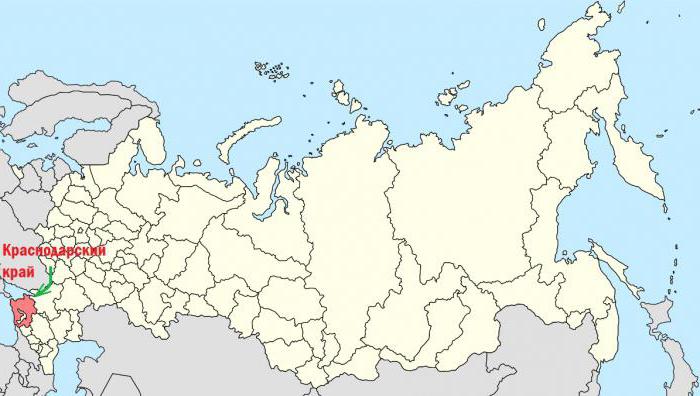
The Area of the Krasnodar region under the Russian standards of small-75.5 thousand square kilometers. This is slightly lower than Czech Republic, but more than any of the Baltic countries. The region borders with Rostov oblast in the North, Stavropol Krai to the East, Karachay-Cherkess Republic in the South-East and Abkhazia in the South. In addition, in its territory, an enclave situated on the Republic of Adygea.
Recommended

"Knowledge is light and ignorance is darkness": the value, meaning and alternatives
There are some sayings that would seem to need no explanation, such as “teaching & ndash; light and ignorance – darkness”. But some still do not understand their meaning. But not only for such people is written by our article. I...
What was invented by Mendeleev for the army. The history and fate of the invention
D. I. Mendeleev was a brilliant Russian scientist-polymath, who made many important discoveries in various fields of science and technology. Many people know that he is the author of “Fundamentals of chemistry" and the periodic law of chem...
The origin of the Slavs. The influence of different cultures
Slavs (under this name), according to some researchers, appeared in the story only in 6 century ad. However, the language of nationality bears the archaic features of the Indo-European community. This, in turn, suggests that the origin of the Slavs h...
Today in the Krasnodar region is home to 5.6 million people. The largest city of the region-Krasnodar, Novorossiysk, Sochi, Armavir, Yeysk and Anapa. Edge is in the third time zone (UTC+3). The time difference with Moscow is not.
Geomorphologist divide the territory of this region into two parts: the Northern (lowland) and southern (mountain). The natural border between them is the valley of the Kuban. The Northern and Central expanses of the region occupied by plains, and the southern part of the Krasnodar territory – the foothill strip, and the mountain ranges of the greater Caucasus – fold the largest European countries. It is obvious that there is the highest point of the region – the mountain, Tsahvoa (3345 metres). In the extreme South-East beyond the edge come the spurs of the Stavropol upland.
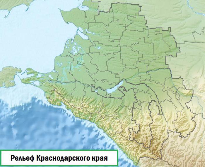
Thus, the topography of the Krasnodar region is extremely diverse. Even more originality give him the low-lying wetlands of the Delta of the Kuban and the unique mud volcanoes of the Taman Peninsula (of which more will be discussed later).
A relatively small area of Krasnodar territory it is possible to meet a wide range of diverse landscapes: desert, forest, mountain-meadow, mountain-glacial, coastal, semiarid and saline. Learn more about the topography of the Krasnodar territory – later in the article.
The Region is located at the junction of three geological units: the southern slopes of the Ukrainian crystalline shield, a young Scythian plate, and geosynclinal zones of the greater Caucasus. This largely explains the tremendous richness of the relief forms of the Krasnodar territory.
In the plains of the region are widely distributed deep river valleys, beams and ravines with quite steep slopes. Some places there are landslides. In General, high density of gully network and significant gradients contribute to the development of erosion processes in this region.
Interesting in geomorphological terms, the Delta of the Kuban river. It formed ploskorezy relief with a predominance of extensive estuaries and lower troughs. Sometimes it is enlivened with low ridges and riparian trees. A significant part of the Delta of the Kuban today is actively used (in particular for rice cultivation).
Karst topography Krasnodar region is represented by caves, mines, and craters. These forms are widely distributed in the southern part of the region, in the mountains and foothills of the Caucasus. In the geological structure of those territories is dominated by limestone, therefore karst processes here are particularly active. Should especially highlight the ridge Alec, which stretches along the sea coast. Within it discovered at least 40 karst shafts and caves.
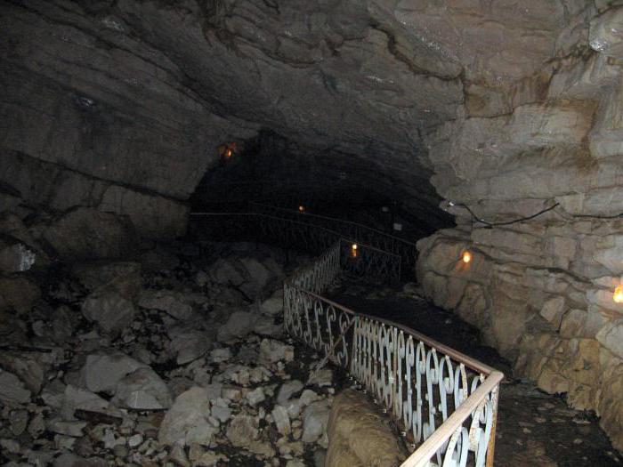
The black sea coast of Krasnodar region is densely cut by narrow, canyon-like valleys of mountain rivers, here referred to as gaps. Of particular interest is the gap of the river Mzymta. The width of this canyon is 30 meters, but the height is 800 meters.
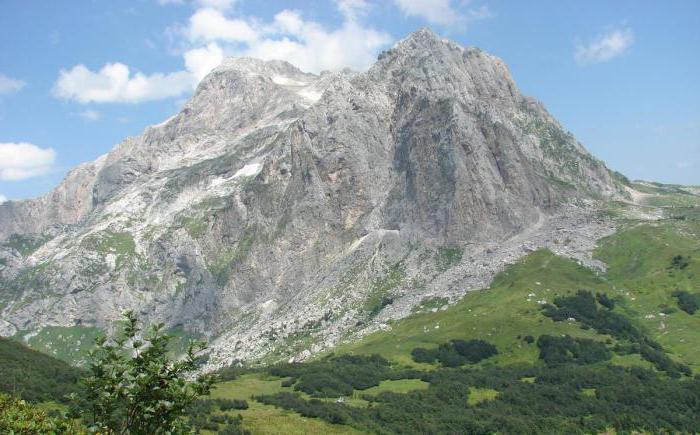
Within the Krasnodar Krai mountains occupy approximately one-third of its total territory. They start low hills in the vicinity of Anapa and extend in a South-easterly direction up to the border with Abkhazia, gradually gaining altitude. In the heart of the city-resort Sochi height of the Caucasus mountains, reaches 3,000 meters above sea level.
The Mountains of the greater Caucasus are part of the young Alpine-Himalayan fold belt. The Northern slopes of the ridge is flatter than the South, which are coolbreak to the sea. The Central part of the Caucasus mountains is composed of ancient (gneisses, granites, diorites), and the slopes – younger rocks (mainly limestones, sandstones, Dolomites and marls).
The highest point of the greater Caucasus in the limits of Krasnodar territory – the mountain, Tsahvoa. It is in the Mostovsky district and crowning the ridge of Herzen. On the Northern slope of the mountains sprawled one of the largest glaciers territory with an area of 2.5 sq. km. Other famous peaks of the Krasnodar territory – Coughs, Caraguata, and fischt Oshten.
The Plain stretches from the coast of the sea of Azov and the Kuban valley to the North of the administrative borders of the Krasnodar territory. In literature another title – Kuban-Azov lowland. It is based on a young Scythian plate with a rather thick sediment cover. Therefore, the basic rocks of the lowland – the clays and loess-like loam.
The Azov-Kuban plain is inclined to the North-West. In this direction, its absolute height is gradually reduced from 250 to 0 meters. The coast of the Azov sea and the landscape of the plains is complicated by the numerous sleeves Kuban deltas, estuaries, marshes, and boggy land.
In the North-Western part of the valley there are deposits of natural gas.
Taman Peninsula situated between the Black and Azov seas. The Kerch Strait separates it from the nearby Crimean Peninsula. Low-lying terrain of Taman complicated meander by ramparts, the lonely hills, sand spits and estuaries. Coast of the Peninsula, composed of limestone and limestone, in some places abruptly break to the sea.
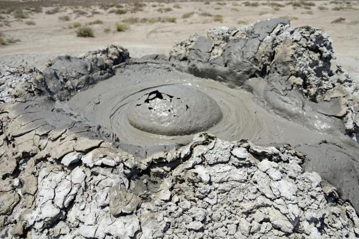
But the main highlight of the Taman Peninsula – mud volcanoes. Here there are at least 30 pieces. From their bowels they throw out is not molten lava, but slightly warm therapeutic mud. The largest mud volcano of Taman – Akhtanizovskaya of Bleach. Its height – 67 metres, and the crater diameter-23 meters.
The Climate in most part of Krasnodar region is moderately continental (only on a narrow strip of black sea coast – subtropical Mediterranean). In the mountains is clearly expressed climate and temperature zoning. For the Northern foothills of the Caucasus is characteristic of the so-called dryers – warm and dry winds blowing from the mountains into the valley. In the spring they accelerate the melting of the snow cover. Summer in the Krasnodar region are hot, and winters-quite mild. Average annual precipitation ranges widely (from 350 mm in the plains to 3,000 mm in the mountains).
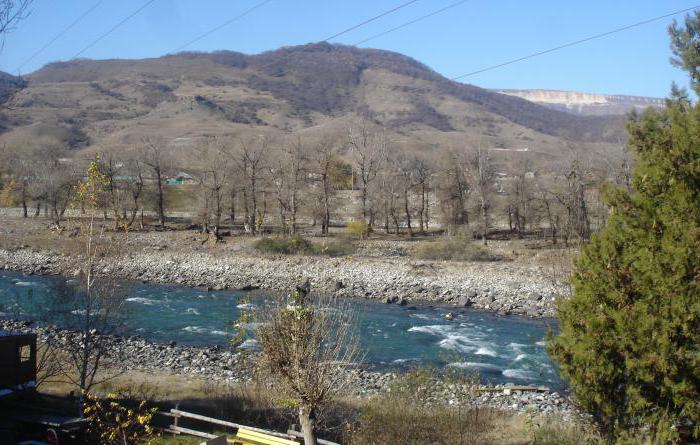
The Hydrographic network is more developed in the southern part of the region. The largest river of the region-Kuban. It originates on the slopes of mount Elbrus-the highest mountain in Europe. The length of the Kuban river within the Krasnodar region is 662 km, the total length – 870 km of Other major watercourses in the region – Her Beysug, Kirpili, Mzymta.
In the mountainous areas there are many karst lakes. But their size is small. On the coast of the Azov sea common lake estuary type.
In between swimming in the sea and sunbathing, guests of the Krasnodar region have the opportunity to visit the many interesting natural objects. Here is a list of the main and most visited natural attractions in this region:
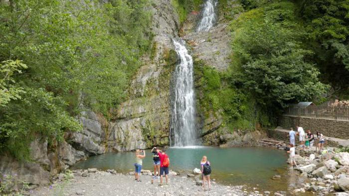
Varied terrain, mild climate, mountains and the sea – all of these factors draw in Krasnodar Krai huge number of tourists. No wonder here is the main summer resorts in the country – Sochi, Anapa, Gelendzhik, Yeysk and other.
Article in other languages:
KK: https://tostpost.com/kk/b-l-m/18103-geografiyaly-orny-zh-ne-zher-beder-krasnodar-lkes.html
PT: https://tostpost.com/pt/educa-o/18073-a-geografia-e-a-topografia-da-regi-o-de-krasnodar.html
TR: https://tostpost.com/tr/e-itim/18114-co-rafi-konumu-ve-arazi-krasnodar.html
UK: https://tostpost.com/uk/osv-ta/18100-geograf-chne-polozhennya-rel-f-krasnodars-kogo-krayu.html

Alin Trodden - author of the article, editor
"Hi, I'm Alin Trodden. I write texts, read books, and look for impressions. And I'm not bad at telling you about it. I am always happy to participate in interesting projects."
Related News

Explanation: forming dew, frost, rain and snow
Water - the basis of life on planet Earth. Its cycle in nature makes you think about how dew formed, frost, rain and snow. Changes in temperature and pressure contribute to the rapid crystallization of the particles of the liquid....
The Kuzminsky cemetery - memory of the builders of Tsarskoye Selo
the kuzminskoye cemetery is one of the oldest in the Leningrad region. Its name is derived from the eponymous settlement, which was near the river Kuzminki in the XVIII century. Then, in the fifties of the same century, it became ...
In Russia there are a huge number of medical schools. And the best of them is located in Moscow. It is named after the famous Russian specialist, anatomist and surgeon, founder of the Russian military-field surgery-Nikolai Ivanovi...
Surface tension: overview and biological significance
Between the molecules of the liquid there are forces of adhesion, different surface and deep (inner) layers. The molecules on the surface layer, get a one-way attraction from the deep layers and in deep layers of the forces of att...
Decimal fractions in math represent a rational number that is equal to one, and multiple lobes, which are divided from a particular unit. The entry of this index typically contains two numbers. The first specifies how it shares br...

Why does the Moon not fall to Earth? A detailed analysis
the article tells about why the Moon does not fall to the Ground, causes her movements around the Earth and some other aspects of celestial mechanics of our Solar system.the space agethe Natural satellite of our planet has always ...


Comments (0)
This article has no comment, be the first!